| Flush Bracket | Description | Height (ft AOD) | Grid Ref | Page |
| Brentford to Harrow-on-the-Hill | | | 7 |
| S1016 | FB on N face of bldg, entrance to Hanwell Co. Lunatic Asylum | 69.279 | TQ 1470 8015 | 7 |
| S1019 | FB on NW angle of Mill Cottage | 58.993 | TQ 1428 8059 | 7 |
| S1020 | FB on NE angle of building, RC Presbytery, W side of road | 79.937 | TQ 1440 8240 | 7 |
| S1021 | FB on S face of building, E side of road, at junction of roads | 64.203 | TQ 1462 8272 | 7 |
| British Museum to Ware | | | 8 |
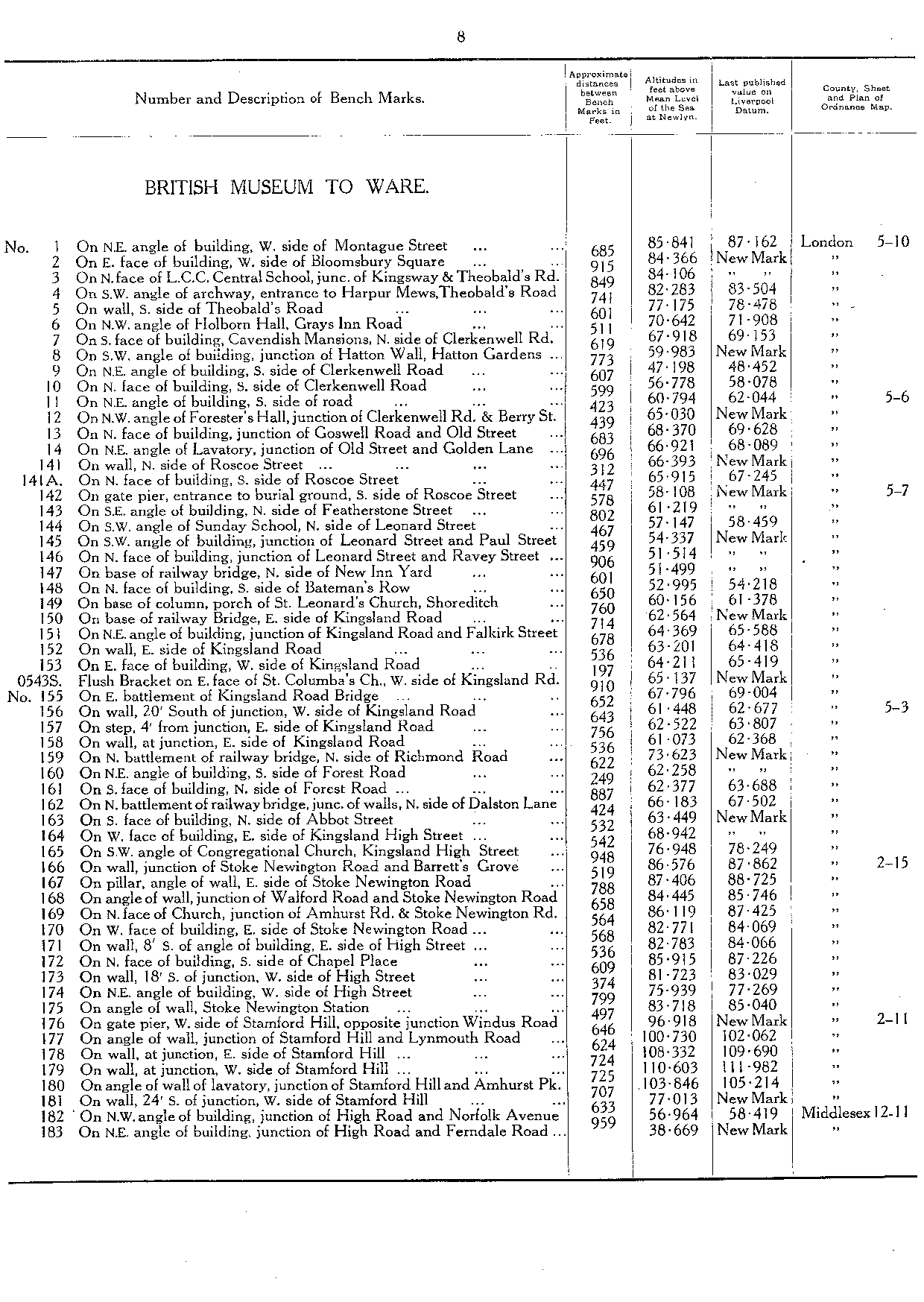
| S0543 | FB on E face of St. Columba's Church, W side of Kingsland road | 65.137 | TQ 3347 8345 | 8 |
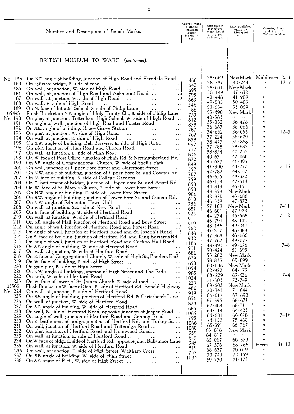
| S0544 | FB on NE angle of Holy Trinity Church, S side of Philip Lane | 55.49 | TQ 3373 8950 | 9 |
| S0550 | FB on W face of School, E side of Hertford Road, Enfield Highway | 69.602 | TQ 3526 9723 | 9 |
| British Museum to Tilbury | | | 11 |
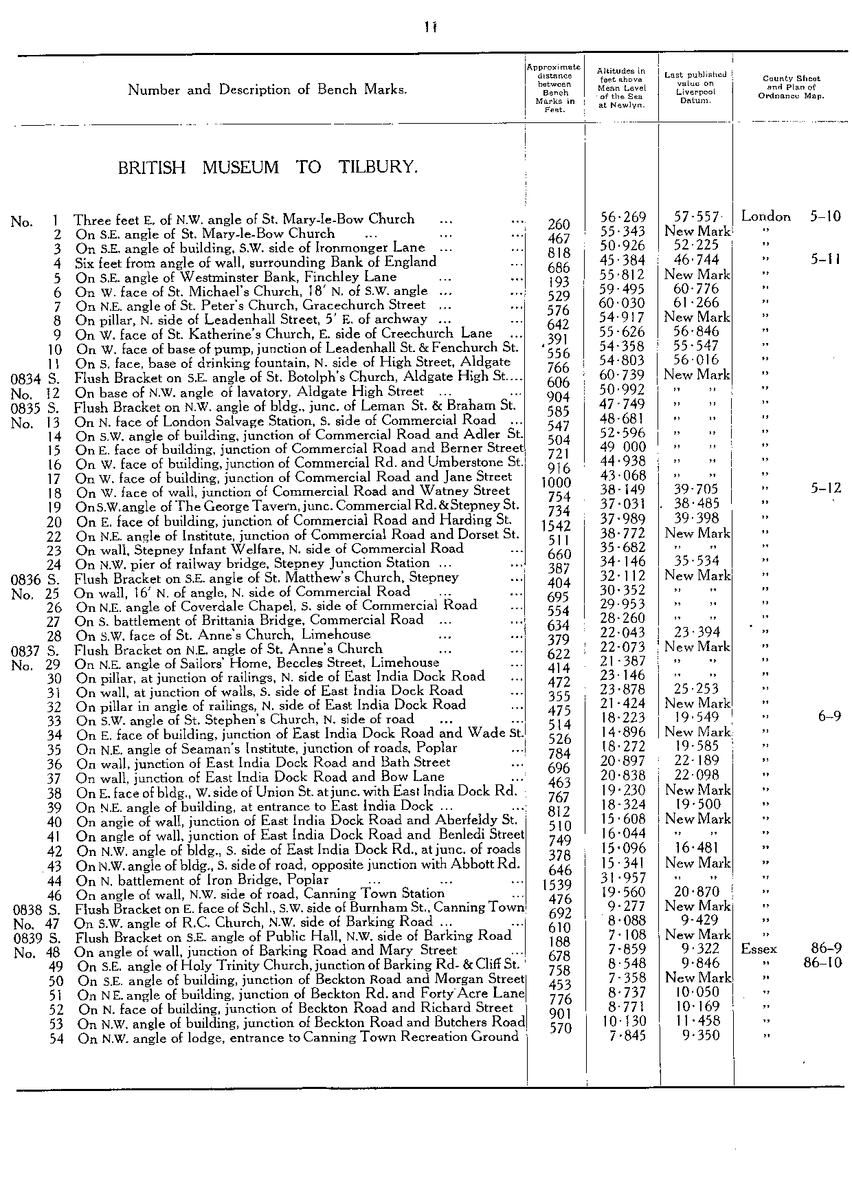
| S0834 | FB on SE angle of St Botolph's Church, Aldgate High Street | 60.739 | TQ 3359 8119 | 11 |
| S0835 | FB on NW angle of building, junc of Leman Street, and Braham Street | 47.749 | TQ 3396 8128 | 11 |
| S0836 | FB on SE angle of St Matthew's Church, Stepney | 32.112 | TQ 3625 8117 | 11 |
| S0837 | FB on NE angle of St Anne's Church | 22.073 | TQ 3678 8105 | 11 |
| S0838 | FB on E face of School, SW side of Burnham Street, Canning Town | 9.277 | TQ 3946 8137 | 11 |
| S0839 | FB on SE angle of Public Hall, NW side of Barking Road | 7.108 | TQ 3964 8179 | 11 |
| S0840 | FB on W face of Parsonage House, N side of Beckton Road, West Ham | 10.092 | TQ 4076 8180 | 12 |
| S0841 | FB on SE angle of Laundry, East Ham Isolation Hospital | 11.673 | TQ 418 823 | 12 |
| S0842 | FB on N face of building, Colour Works, SE side of road | 15.771 | TQ 4444 8295 | 12 |
| S0843 | FB on NW angle of building, opposite junction of Gascoigne Road | 7.437 | TQ 4467 8308 | 12 |
| S0844 | FB on SE angle of building, N side of road, at junction of roads | 16.861 | TQ 4844 8356 | 12 |
| S0845 | FB on NE angle of Chequers PH, S side of Ripple Road | 18.91 | TQ 4905 8355 | 12 |
| S0846 | FB on NW angle of tower of St Helen & St Giles Church, Rainham | 20.205 | TQ 5213 8220 | 12 |
| S0847 | FB on SE angle of building, junction of Wennington Road and Melville Road | 22.561 | TQ 5258 8204 | 12 |
| S0875 | FB on NW angle of School, junction of roads, Purfleet | 61.442 | TQ 5524 7867 | 12 |
| S0876 | FB on NE angle of building, adjoining Royal Hotel, SW side of road | 31.574 | TQ 5505 7830 | 12 |
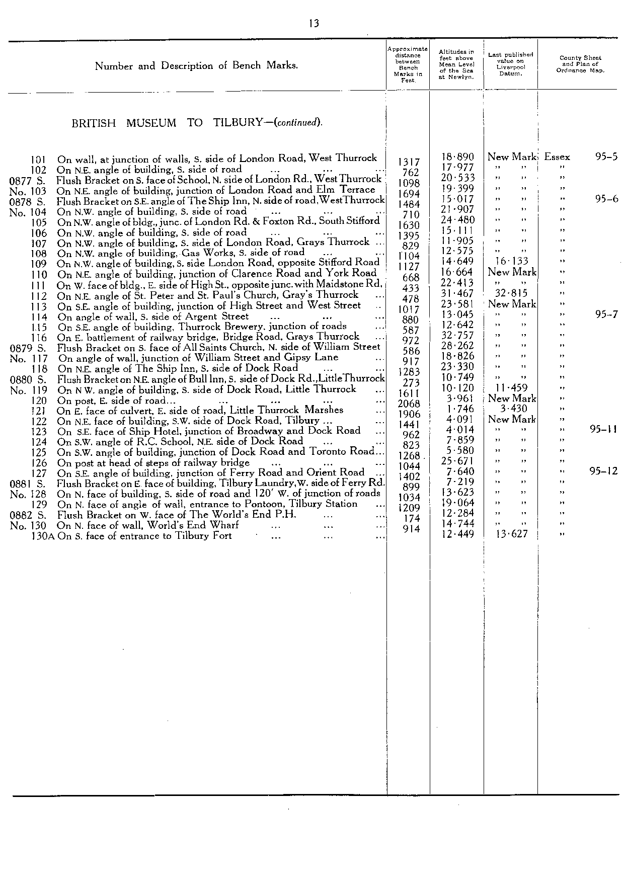
| S0877 | FB on S face of School, N side of London Road, W Thurrock | 20.533 | TQ 5837 7775 | 13 |
| S0878 | FB on SE angle of The Ship Inn, N side of road, W Thurrock | 15.017 | TQ 5918 7781 | 13 |
| S0879 | FB on S face of All Saints Church, N side of William Street [Grays] | 28.262 | TQ 6199 7772 | 13 |
| S0880 | FB on NE angle of Bull Inn, S side of Dock Road, Little Thurrock | 10.749 | TQ 6289 7792 | 13 |
| S0881 | FB on E face of building, Tilbury Laundry, W side of Ferry Road | 7.219 | TQ 6426 7547 | 13 |
| S0882 | FB on W face of The World's End PH [Tilbury] | 12.284 | TQ 6482 7527 | 13 |
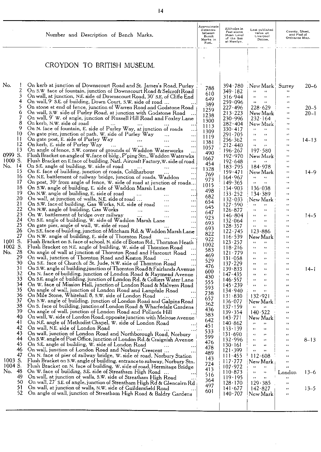
| Croydon to British Museum | | | 14 |
| S0999 | FB on angle of W face of building, P'ping Stn, Waddon Waterworks | 192.97 | TQ 3135 6392 | 14 |
| S1000 | FB on E face of building, Nat'l Aircraft Factory, W side of road | 192.648 | TQ 3114 6401 | 14 |
| S1001 | FB on S face of School, N side of Boston Road, Thornton Heath | 123.257 | TQ 3099 6713 | 14 |
| S1002 | FB on NE angle of building, W side of Thornton Road | 118.216 | TQ 3080 6722 | 14 |
| S1003 | FB on SW angle of building, entrance to subway, Norbury Station | 117.777 | TQ 3066 6975 | 14 |
| S1004 | FB on N face of building, W side of road, Hermitage Bridge | 107.972 | TQ 3049 6993 | 14 |
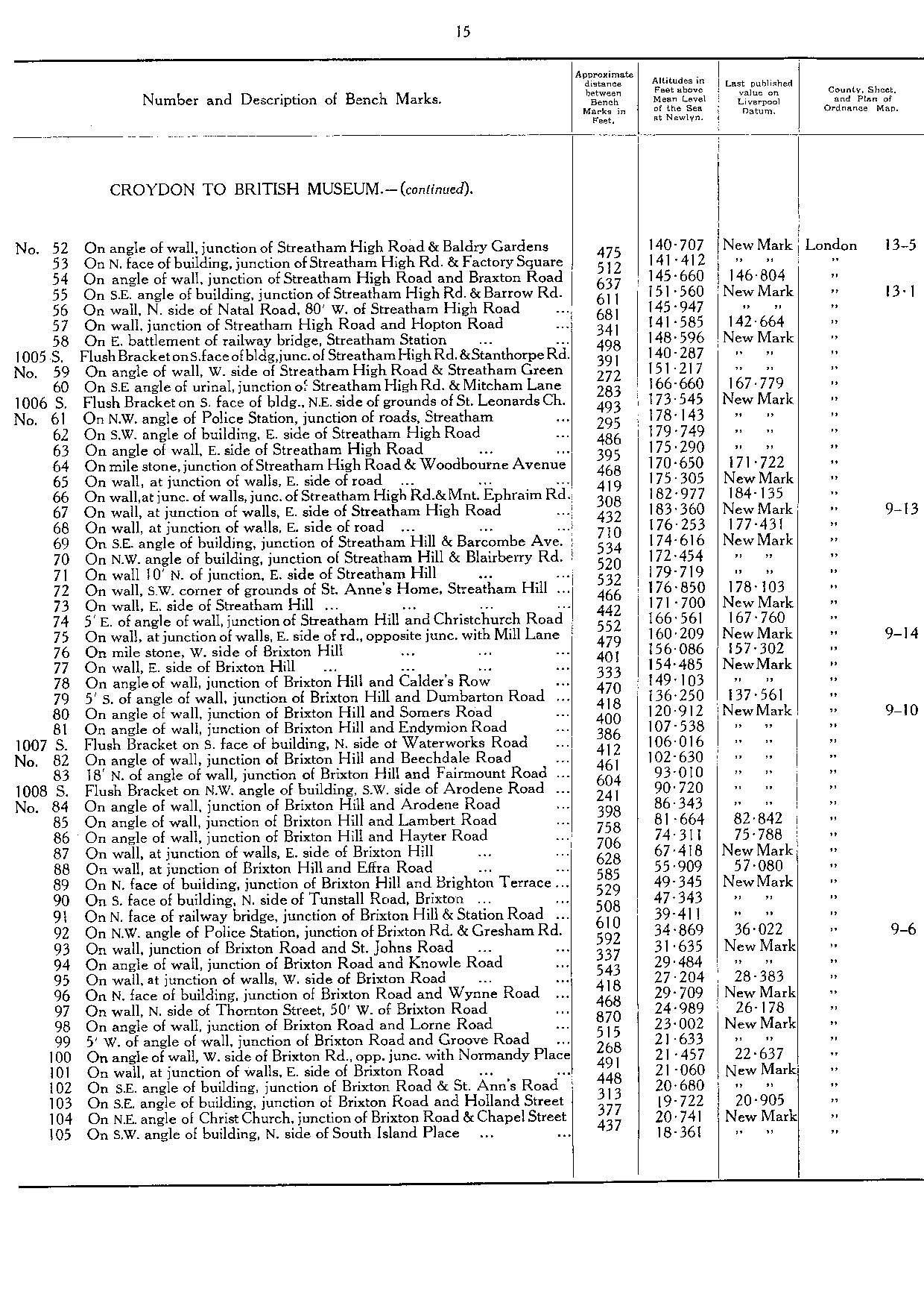
| S1005 | FB on S face of building, junction of Streatham High Road, and Stanthorpe Road | 140.287 | TQ 3006 7149 | 15 |
| S1006 | FB on S face of building, NE side of grounds of St Leonards Church | 173.545 | TQ 3001 7174 | 15 |
| S1007 | FB on S face of building, N side of Waterworks Road | 106.016 | TQ 3055 7430 | 15 |
| S1008 | FB on NW angle of building, SW side of Arodene Road | 90.72 | TQ 3077 7445 | 15 |
| S1009 | FB on SE angle of building, NE side of Harleyford Road | 15.934 | TQ 3064 7796 | 16 |
| S1010 | FB on SE face of building, junction of Clapham Road and Kennington Road | 15.751 | TQ 3117 7764 | 16 |
| S1011 | FB on N face of building, S side of Westminster Bridge Road | 14.579 | TQ 3155 7940 | 16 |
| S1012 | FB on NE face of building, junction of Waterloo Road and Tower Street | 13.186 | TQ 3143 7960 | 16 |
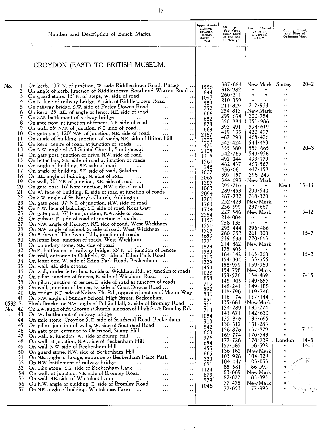
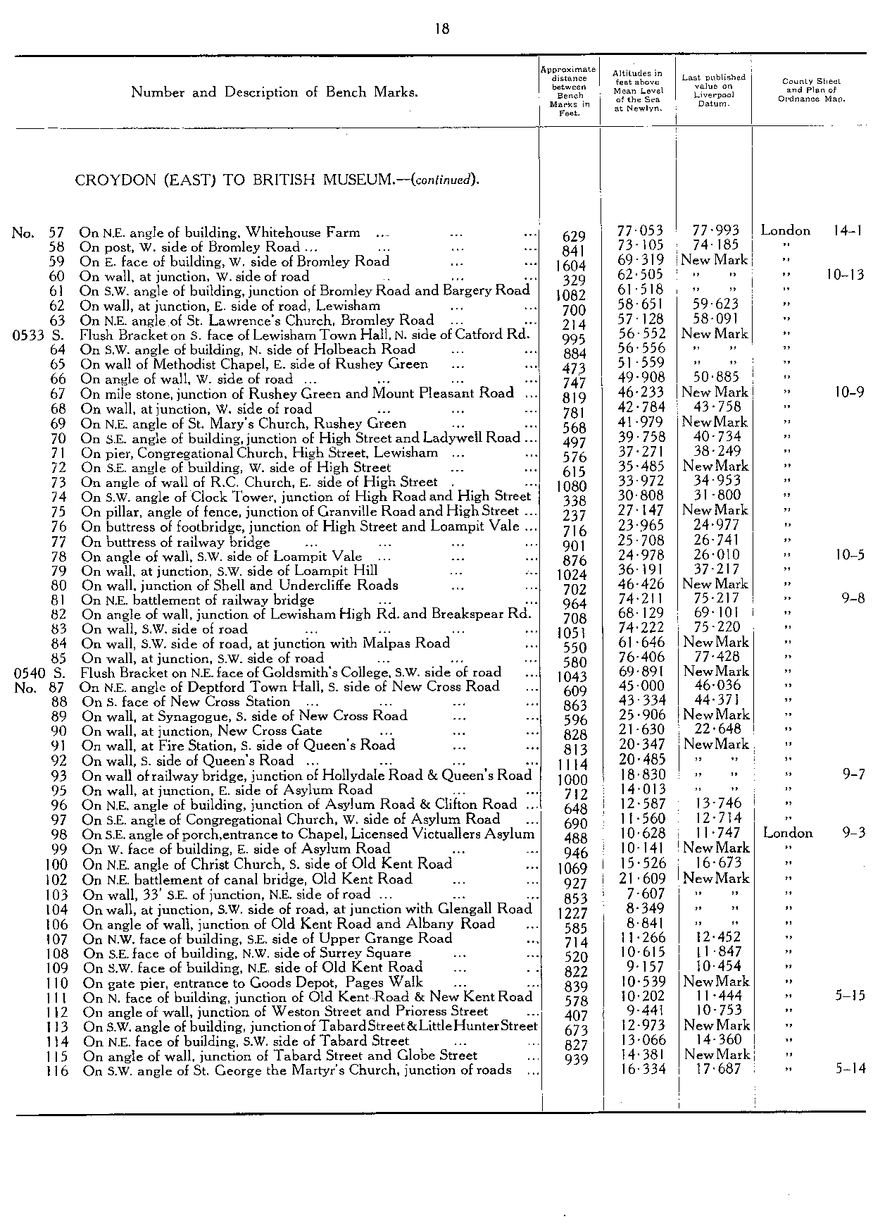
| Croydon (East) to British Museum | | | 17 |
| S0532 | FB on NW angle of Public Hall, S side of Bromley Road | 135.681 | TQ 3749 6957 | 17 |
| S0533 | FB on S face of Lewisham Town Hall, N side of Catford Road | 56.552 | TQ 3763 7365 | 18 |
| S0540 | FB on NE face of Goldsmith's College, SW side of road | 69.891 | TQ 3656 7688 | 18 |
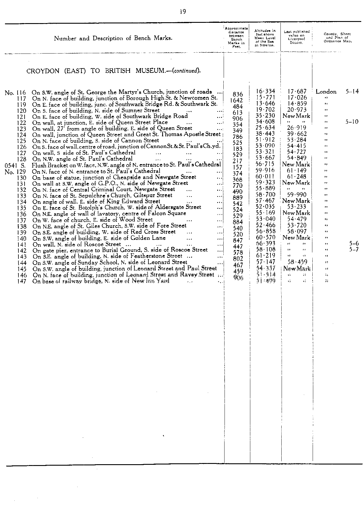
| S0541 | FB on W face, NW angle of entrance to St Pauls's Cathedral | 56.715 | TQ 3204 8117 | 19 |
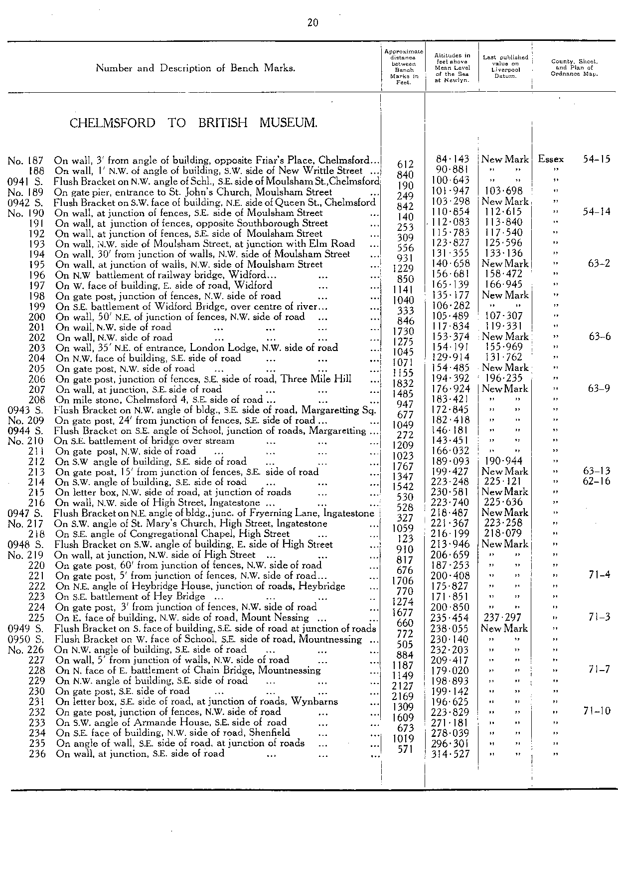
| Chelmsford to British Museum | | | 20 |
| S0941 | FB on NW angle of School, SE side of Moulsham Street, Chelmsford | 100.643 | TL 7064 0614 | 20 |
| S0942 | FB on SW face of building, NE side of Queen's Street, Chelmsford | 103.298 | TL 7056 0612 | 20 |
| S0943 | FB on NW angle of bldg, SE side of road, Margaretting Sq | 172.845 | TL 6719 0175 | 20 |
| S0944 | FB on SE angle of school, junction of roads, Margaretting | 146.181 | TL 6666 0156 | 20 |
| S0947 | FB on NE angle of building, junction of Fryerning Lane, Ingatestone | 218.487 | TQ 6507 9968 | 20 |
| S0948 | FB on SW angle of building, E side of High Street | 213.946 | TQ 6483 9938 | 20 |
| S0949 | FB on S face of building, SE side of road at junction of roads | 238.055 | TQ 6311 9776 | 20 |
| S0950 | FB on W face of school, SE side of road, Mount Nessing | 230.14 | TQ 6292 9764 | 20 |
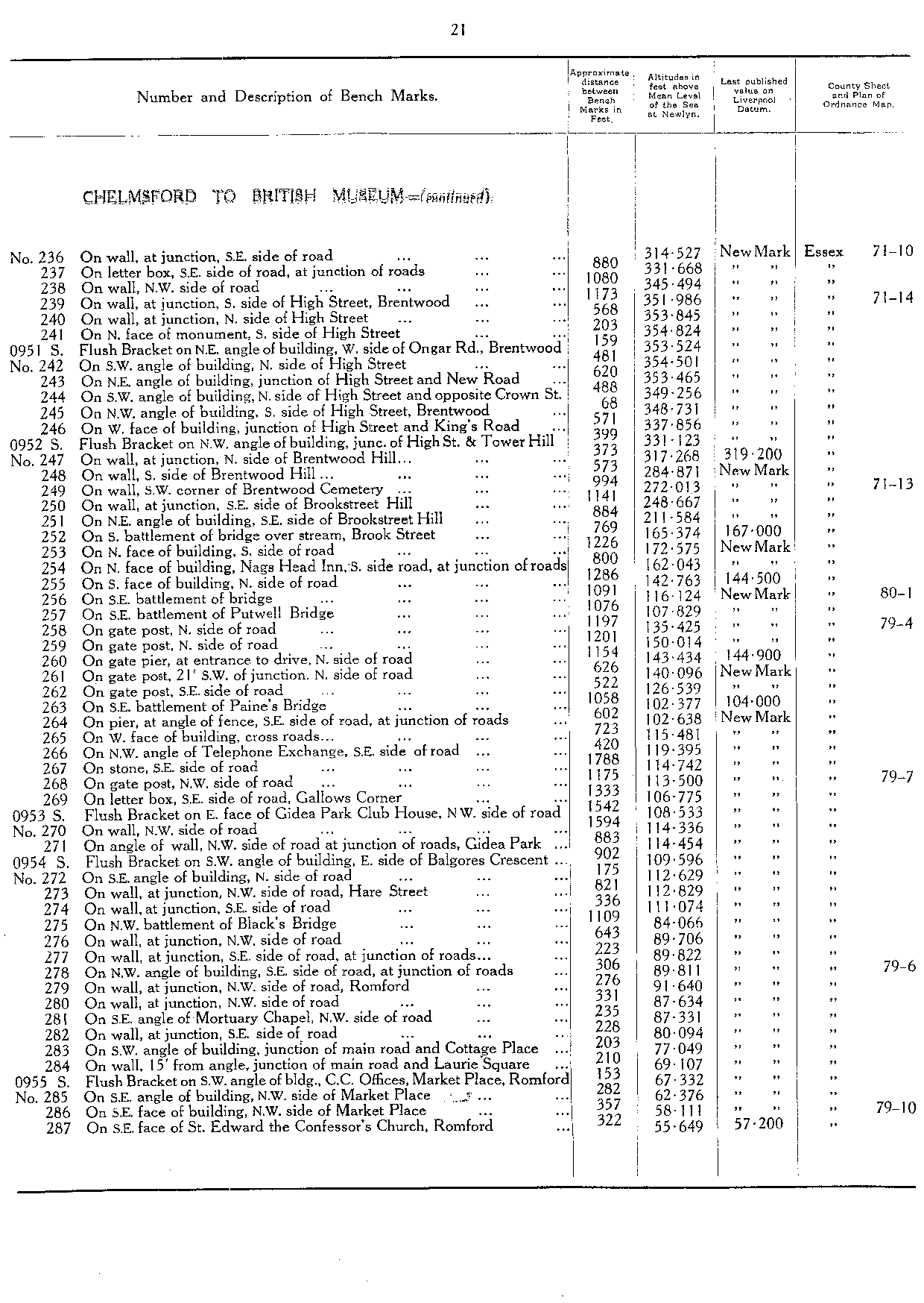
| S0951 | FB on NE angle of building, W side of Ongar Road, Brentwood | 353.524 | TQ 5967 9394 | 21 |
| S0952 | FB on NW angle of building, junction of High Street and Tower Hill [Brentwood] | 331.123 | TQ 5910 9368 | 21 |
| S0953 | FB on E face of Gidea Park Club House, NW side of road | 108.533 | TQ 5317 9042 | 21 |
| S0954 | FB on SW angle of building, E side of Balgores Crescent | 109.596 | TQ 5253 8977 | 21 |
| S0955 | FB on SW angle of building, CC offices, Market Place, Romford | 67.332 | TQ 5135 8903 | 21 |
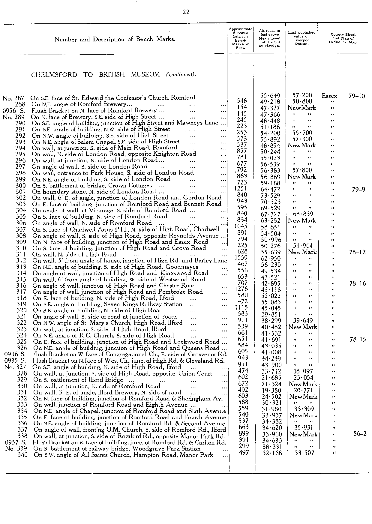
| S0956 | FB on N face of Romford Brewery | 47.327 | TQ 5112 8878 | 22 |
| S0936 | FB on W face of Congregational Church, E side of Grosvenor Road [Ilford] | 41.008 | TQ 4407 8656 | 22 |
| S0935 | FB on N face of Wes Ch, junc of High Road & Cleveland Road | 44.249 | TQ 4382 8648 | 22 |
| S0957 | FB on E face of building, junction of Romford Road & Carlton Road | 34.633 | TQ 4190 8546 | 22 |
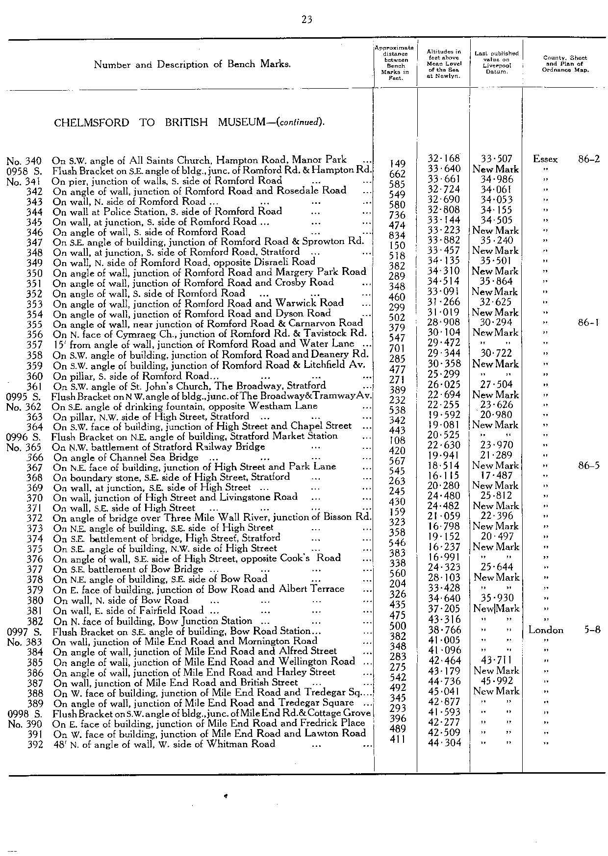
| S0958 | FB on SE angle of building, junc of Romford Road & Hampton Road | 33.64 | TQ 4164 8532 | 23 |
| S0995 | FB on NW angle of bldg, junc of The Broadway & Tramway Avenue | 22.694 | TQ 3898 8434 | 23 |
| S0996 | FB on NE angle of building, Stratford Market Station | 20.525 | TQ 3876 8401 | 23 |
| S0997 | FB on SE angle of building, Bow Road Station | 38.766 | TQ 3723 8286 | 23 |
| S0998 | FB on SW angle of building, junction of Mile End Road and Cottage Grove | 41.593 | TQ 3652 8259 | 23 |
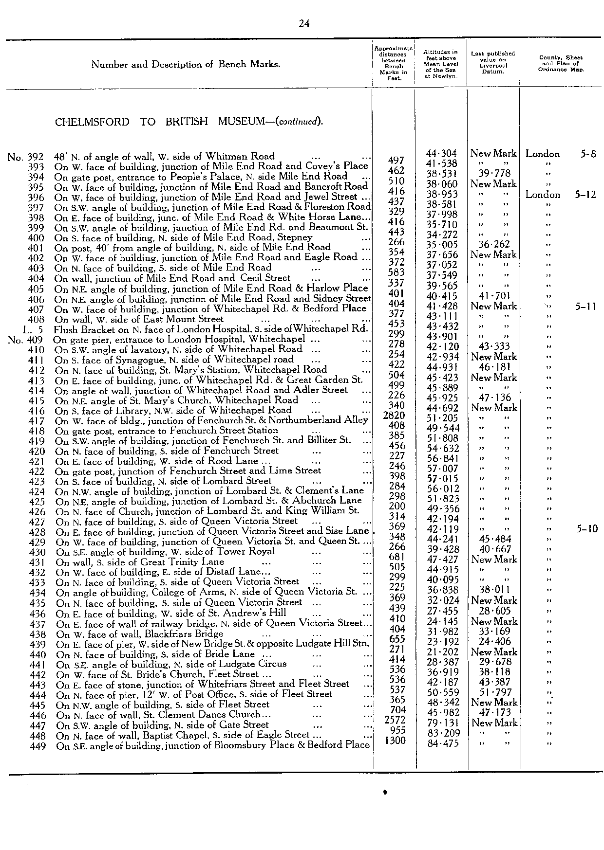
| L5 | FB on N face of London Hospital, S side of Whitechapel Road | 43.432 | TQ 3469 8175 | 24 |
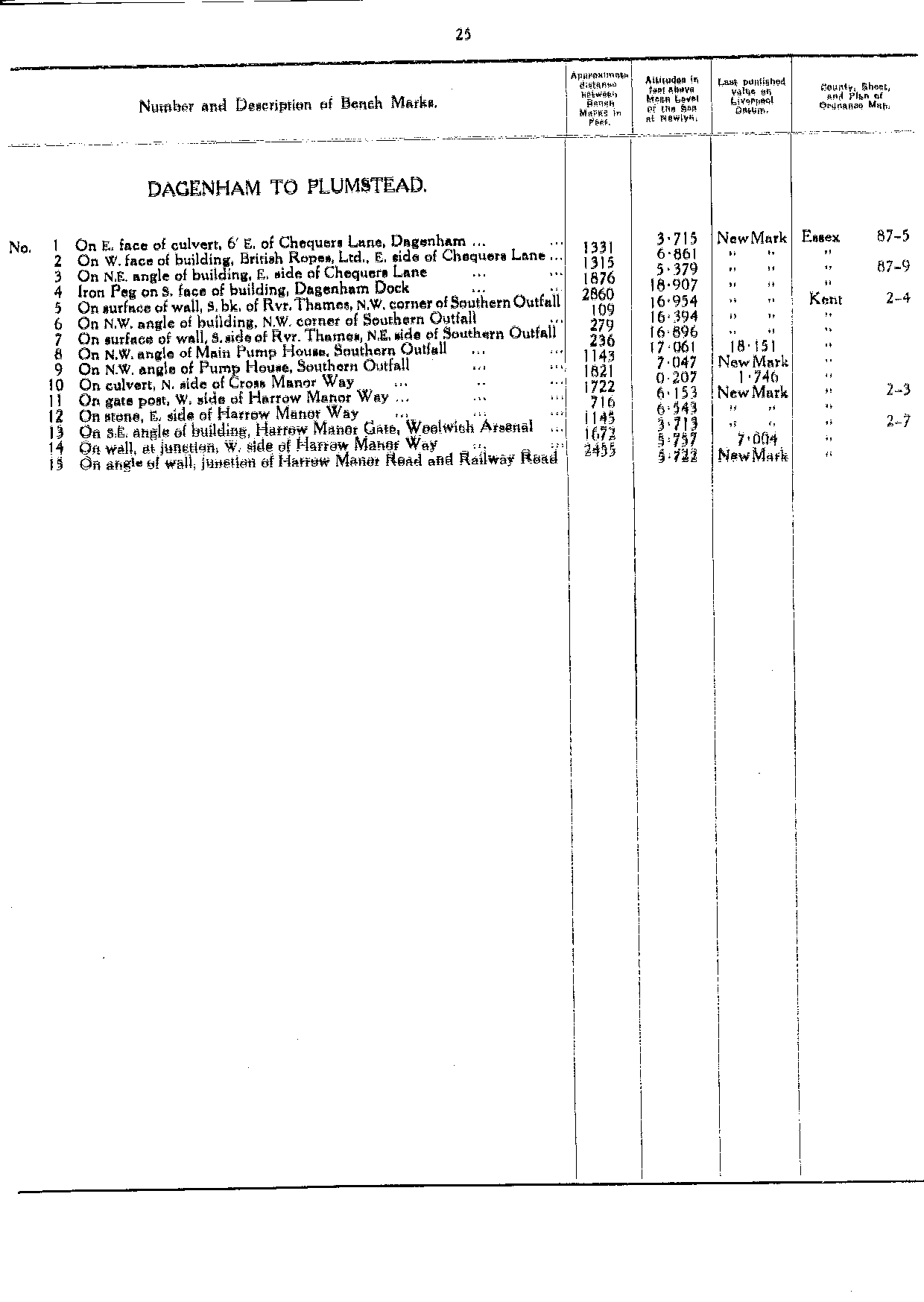
| Dagenham to Plumstead | | | 25 |
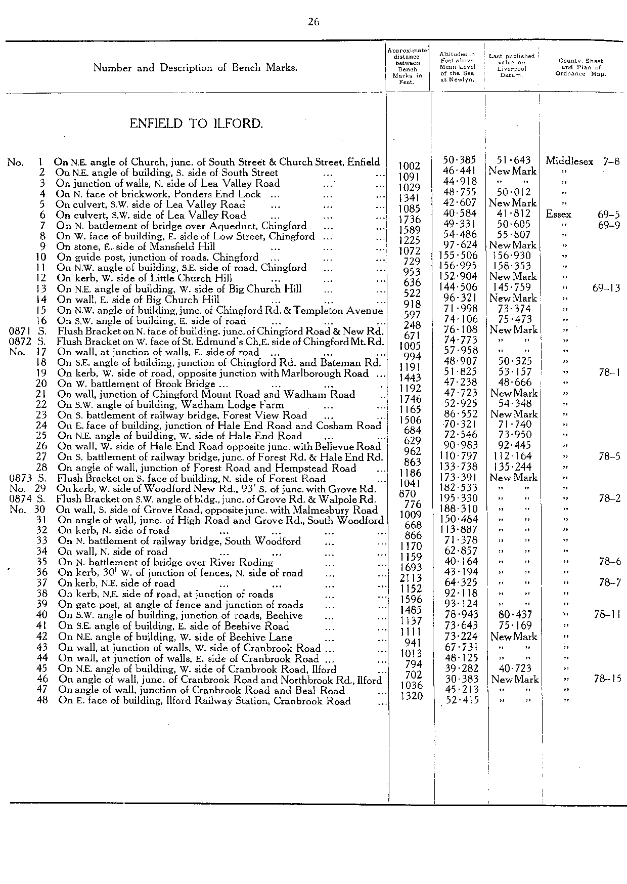
| Enfield to Ilford | | | 26 |
| S0871 | FB on N face of building, junction of Chingford Road & New Road | 76.108 | TQ 3739 9273 | 26 |
| S0872 | FB on W face of St Edmund's Church, E side of Chingford Mount Rd | 74.773 | TQ 3741 9258 | 26 |
| S0873 | FB on S face of building, N side of Forest Road | 173.391 | TQ 3916 9029 | 26 |
| S0874 | FB on SW angle of building, junction of Grove Road & Walpole Road | 195.33 | TQ 3963 9045 | 26 |
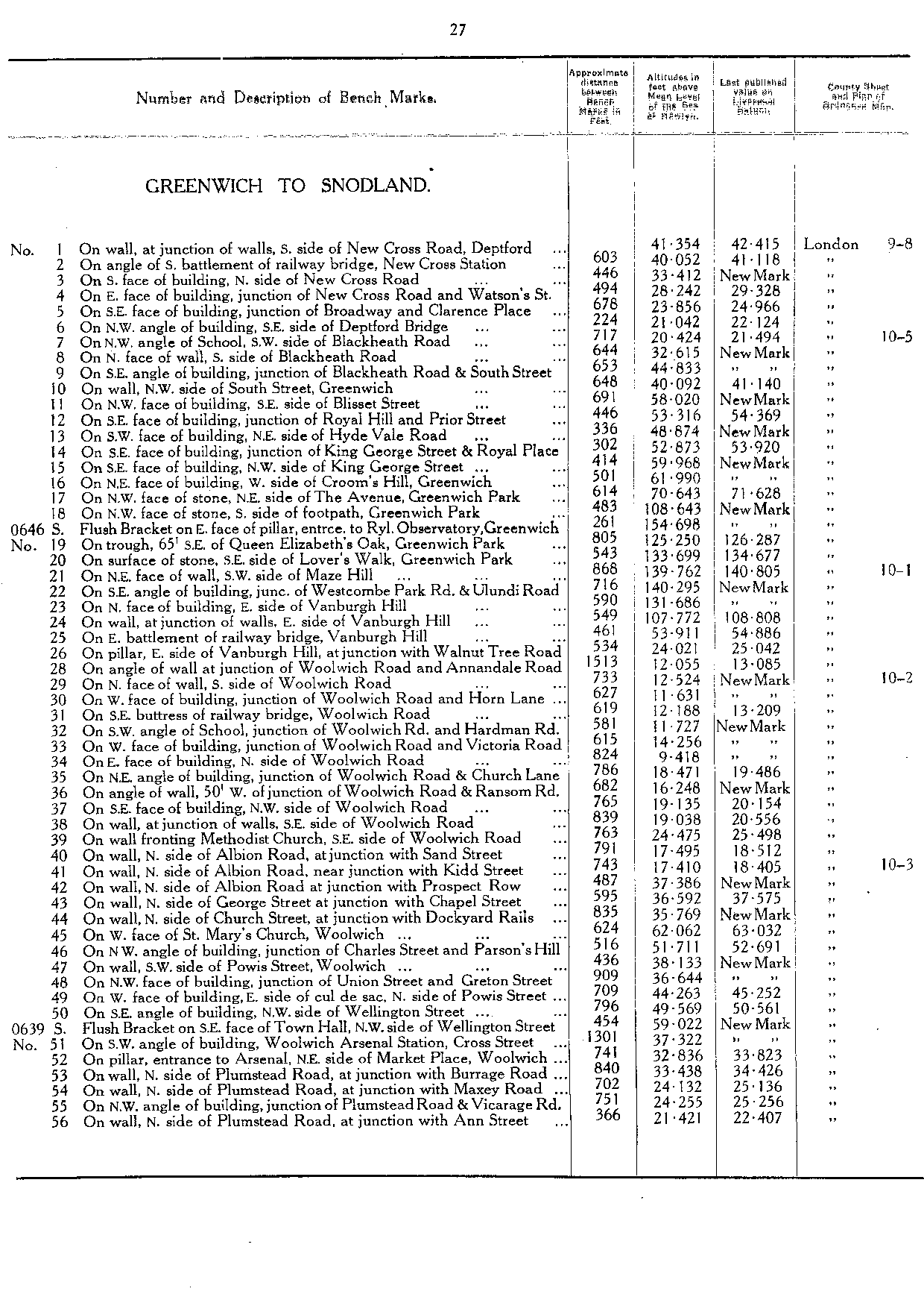
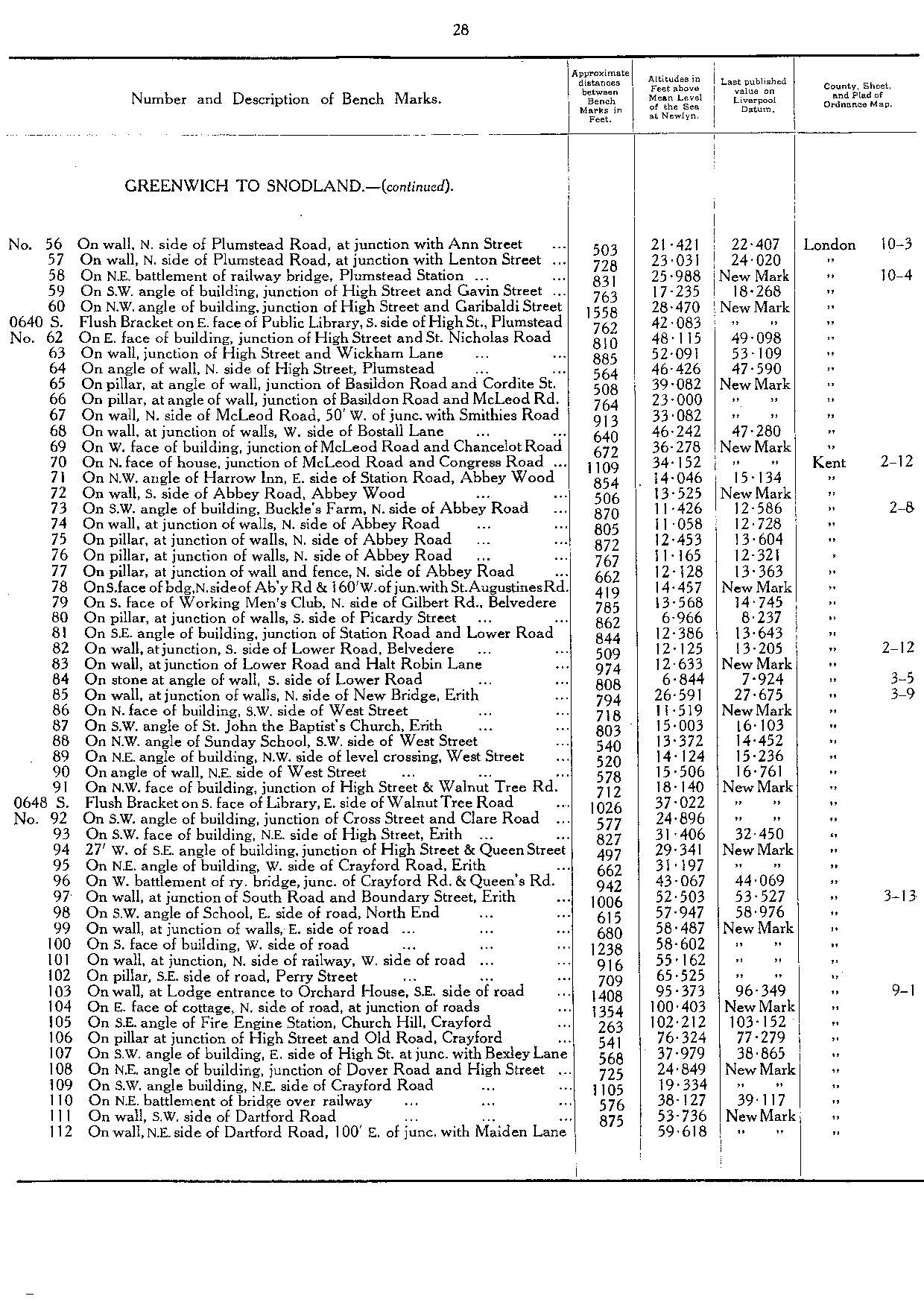
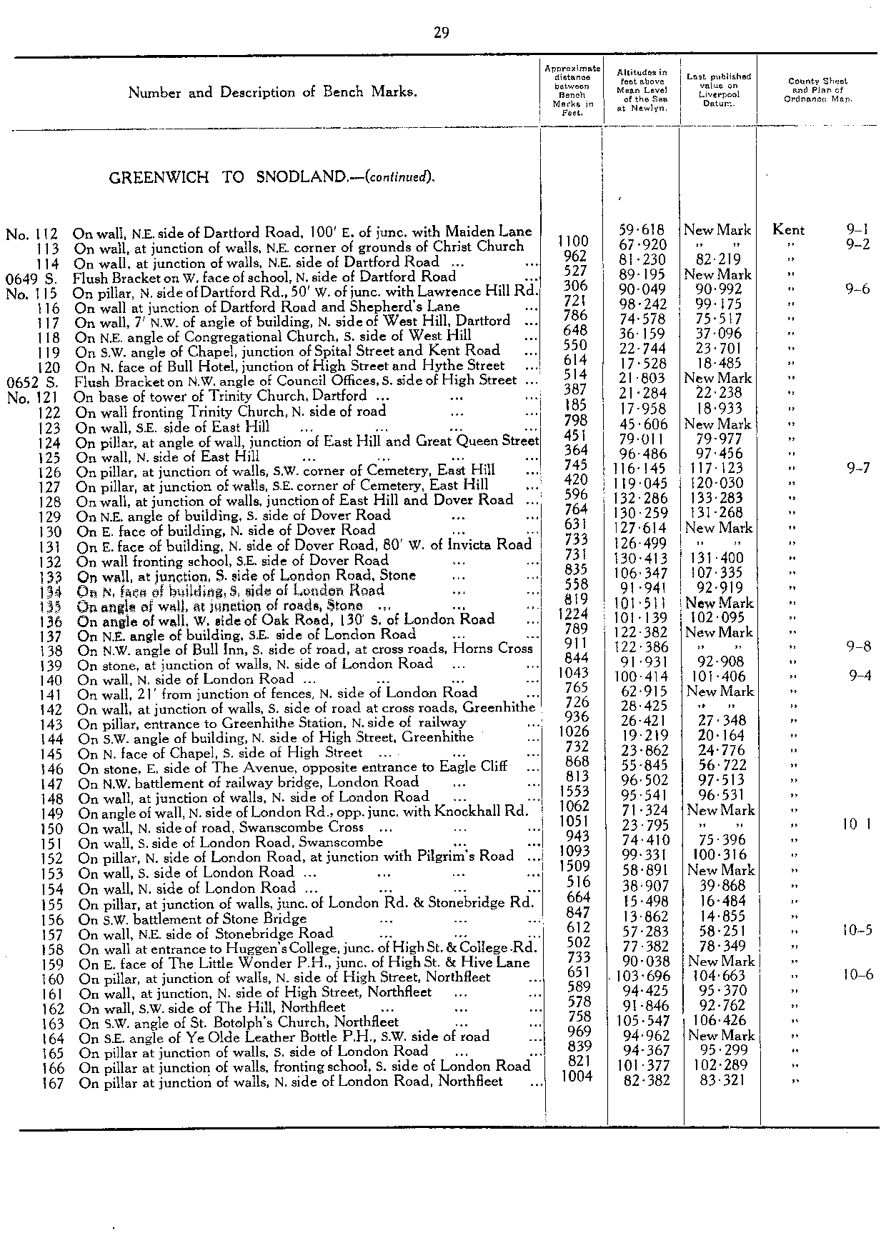
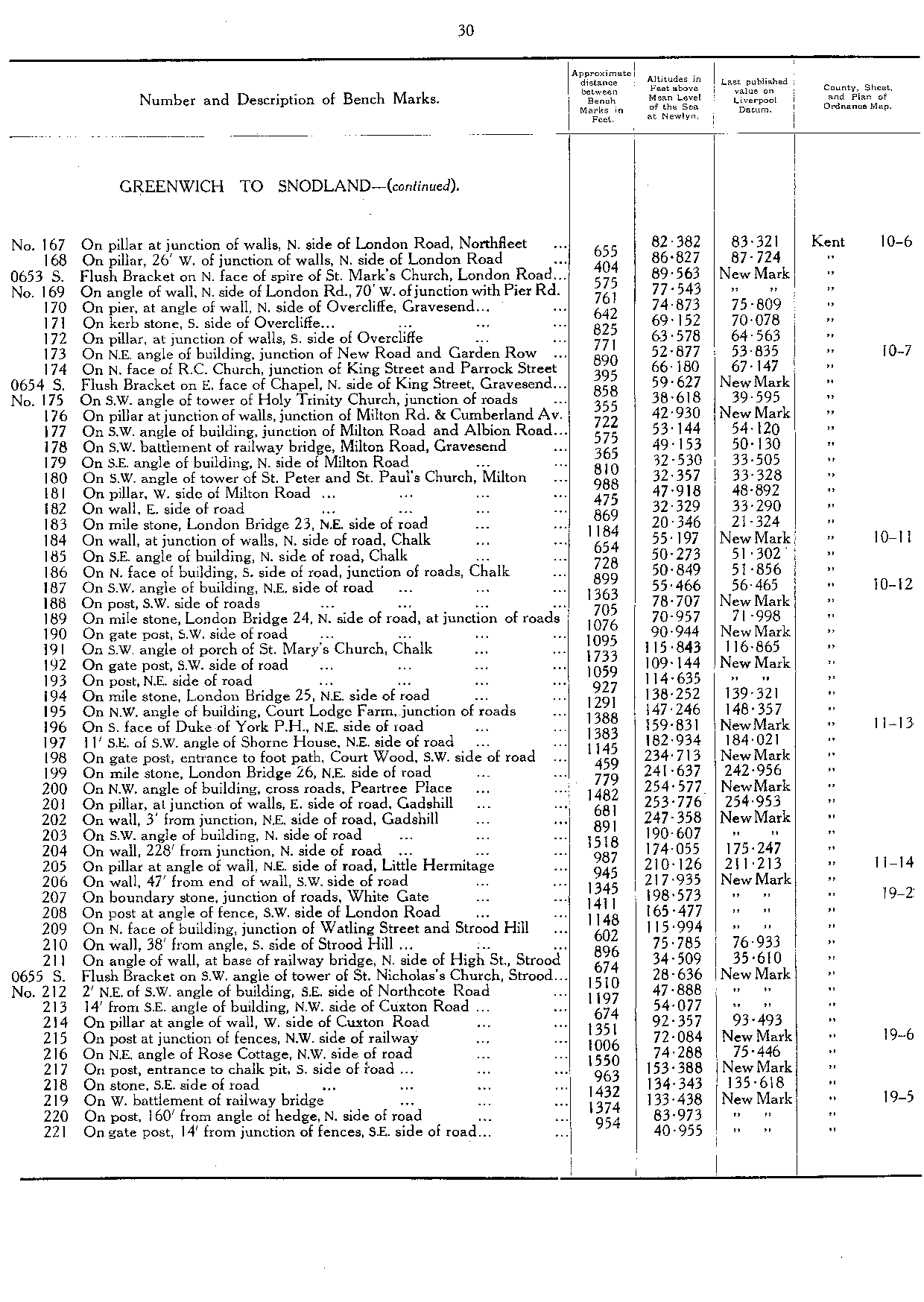
| Greenwich to Snodland | | | 27 |
| S0646 | FB on E face of pillar, entrance to Royal Observatory, Greenwich | 154.698 | TQ 3886 7734 | 27 |
| S0639 | FB on SE face of Town Hall, NW side of Wellington Street [Woolwich] | 59.022 | TQ 4345 7876 | 27 |
| S0640 | FB on E face of Public Library, S side of High Street, Plumstead | 42.083 | TQ 4564 7843 | 28 |
| S0648 | FB on S face of Library, E side of Walnut Tree Road [Erith] | 37.022 | TQ 5134 7807 | 28 |
| S0649 | FB on W face of School, N side of Dartford Road | 89.195 | TQ 5317 7431 | 29 |
| S0652 | FB on NW angle of Council Offices, S side of High Street [Dartford] | 21.803 | TQ 5416 7401 | 29 |
| S0653 | FB on N face of spire, St Mark's Church, London Road [Northfleet] | 89.563 | TQ 6363 7416 | 30 |
| S0654 | FB on E face of Chapel, N side of King Street, Gravesend | 59.627 | TQ 6497 7412 | 30 |
| S0655 | FB on SW angle of tower of St Nicholas's Church, Strood | 28.636 | TQ 7354 6930 | 30 |
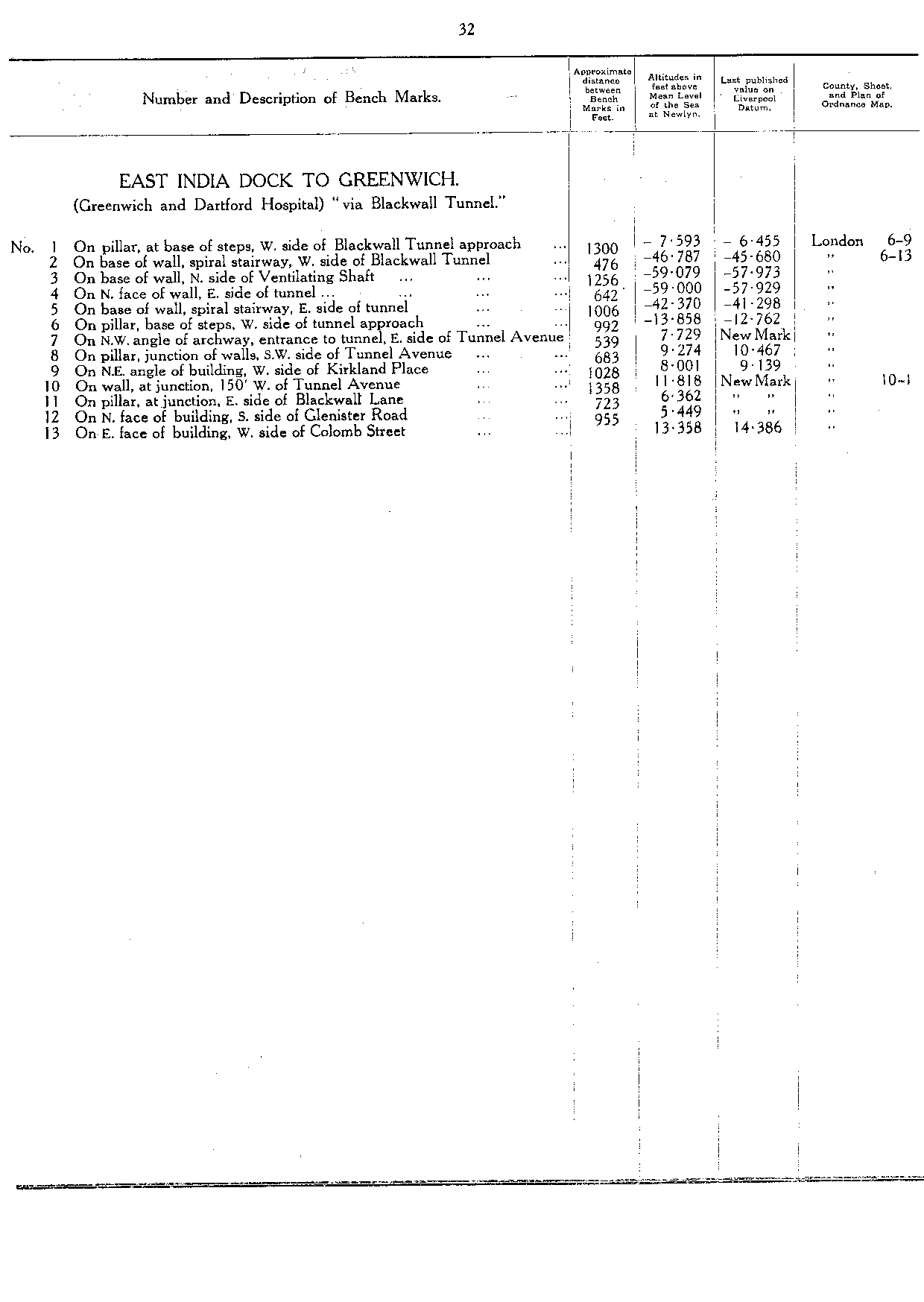
| East India Dock to Greenwich | | | 32 |
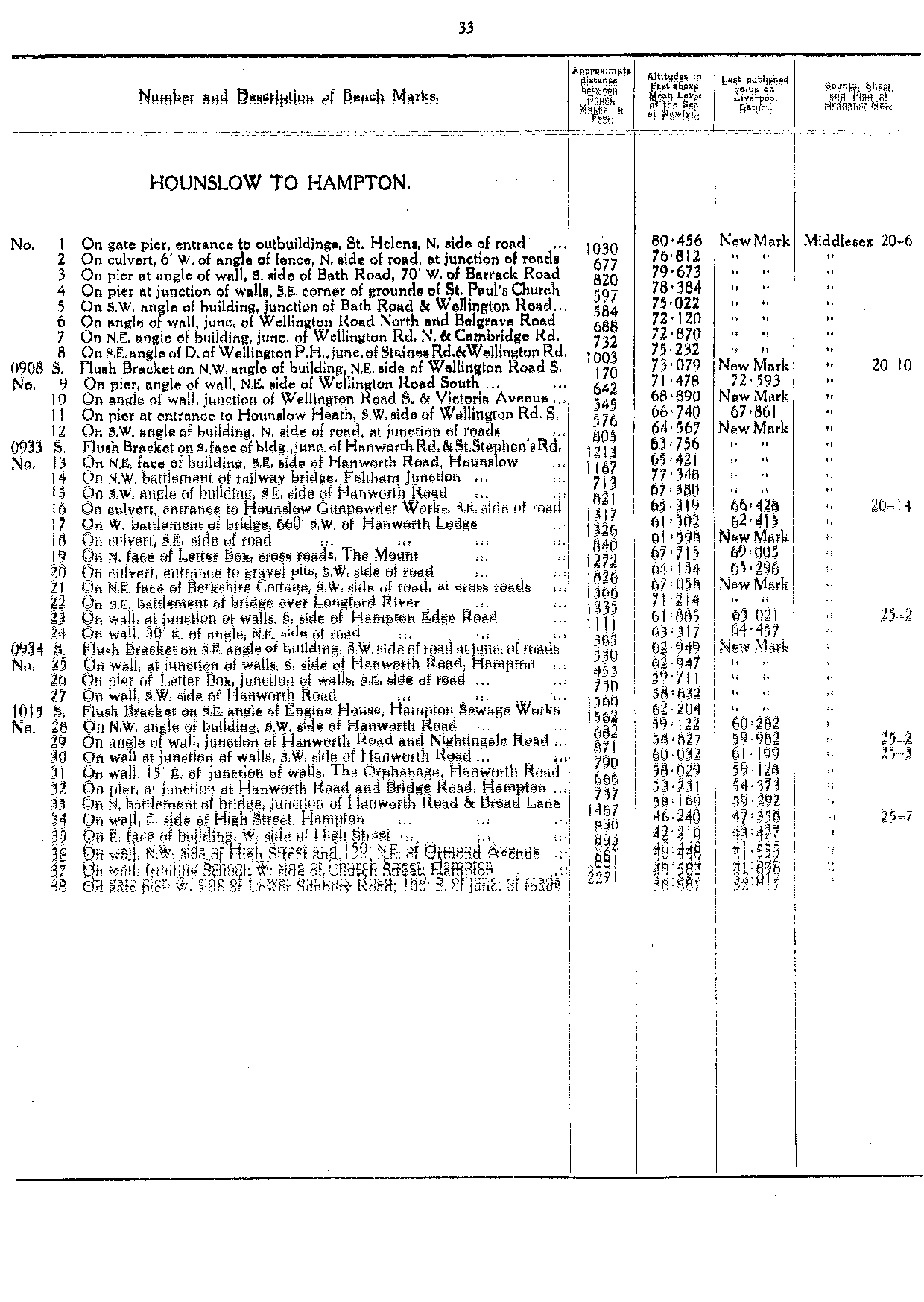
| Hounslow to Hampton | | | 33 |
| S0908 | FB on NW angle of building, NE side of Wellington Road South | 73.079 | TQ 1288 7506 | 33 |
| S0933 | FB on S face of building, junction of Hanworth Road and St Stephen's Road | 63.756 | TQ 1325 7443 | 33 |
| S0934 | FB on SE angle of building, SW side of road at junction of roads | 62.949 | TQ 1253 7160 | 33 |
| S1015 | FB on SE angle of Engine House, Hampton Sewage Works | 62.204 | TQ 1315 7157 | 33 |
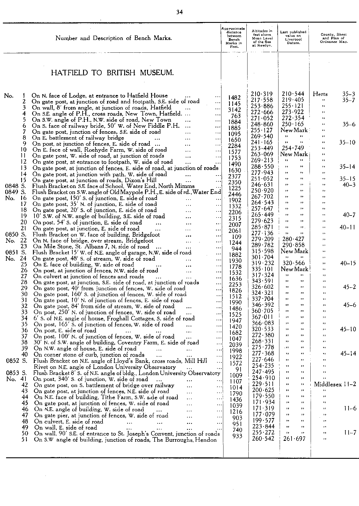
| Hatfield to British Museum | | | 34 |
| S0848 | FB on SE face of School, Water End, North Mimms | 246.631 | TL 2271 0439 | 34 |
| S0849 | FB on SW angle of Old Maypole PH, E side of road, Water End | 250.92 | TL 2297 0410 | 34 |
| S0850 | FB on W face of building, Bridgefoot | 277.136 | TL 2324 0088 | 34 |
| S0851 | FB 15' W of NE angle of garage, NW side of road | 315.598 | TL 2273 0050 | 34 |
| S0852 | FB on NE angle of Lloyd's Bank, cross roads, Mill Hill | 227.646 | TQ 2162 9229 | 34 |
| S0853 | FB 8' S of NE angle of building, London University Observatory | 247.495 | TQ 2177 9198 | 34 |
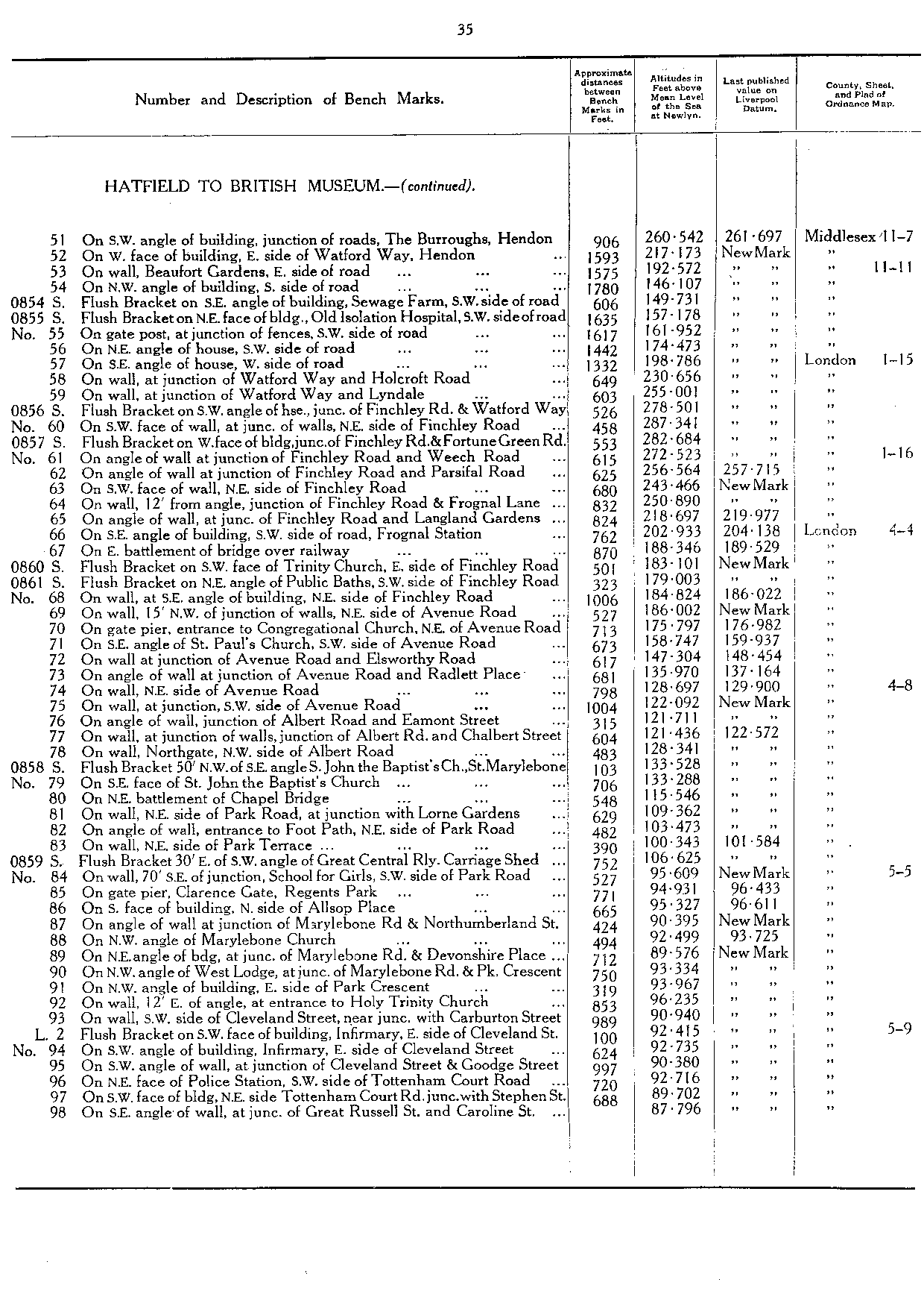
| S0854 | FB on SE angle of building, Sewage Farm, SW side of road | 149.731 | TQ 2382 8773 | 35 |
| S0855 | FB on NE face of building, Old Isolation Hospital, SW side of road | 157.178 | TQ 2393 8759 | 35 |
| S0856 | FB on SW angle of house, junction of Finchley Road & Watford Way | 278.501 | TQ 2511 8605 | 35 |
| S0857 | FB on W face of building, junction of Finchley Road & Fortune Green Road | 282.684 | TQ 2517 8576 | 35 |
| S0860 | FB on SW face of Trinity Church, E side of Finchley Road | 183.101 | TQ 2636 8470 | 35 |
| S0861 | FB on NE angle of Public Baths, SW side of Finchley Road | 179.003 | TQ 2638 8454 | 35 |
| S0858 | FB 50' NW of SE angle, St John the Baptist's Church, St Marylebone | 133.528 | TQ 2716 8290 | 35 |
| S0859 | FB 30' E of SW angle of Great Central Railway, Carriage Shed | 106.625 | TQ 2757 8235 | 35 |
| L2 | FB on SW angle of building, Infirmary, E side of Cleveland Street | 92.415 | TQ 2927 8181 | 35 |
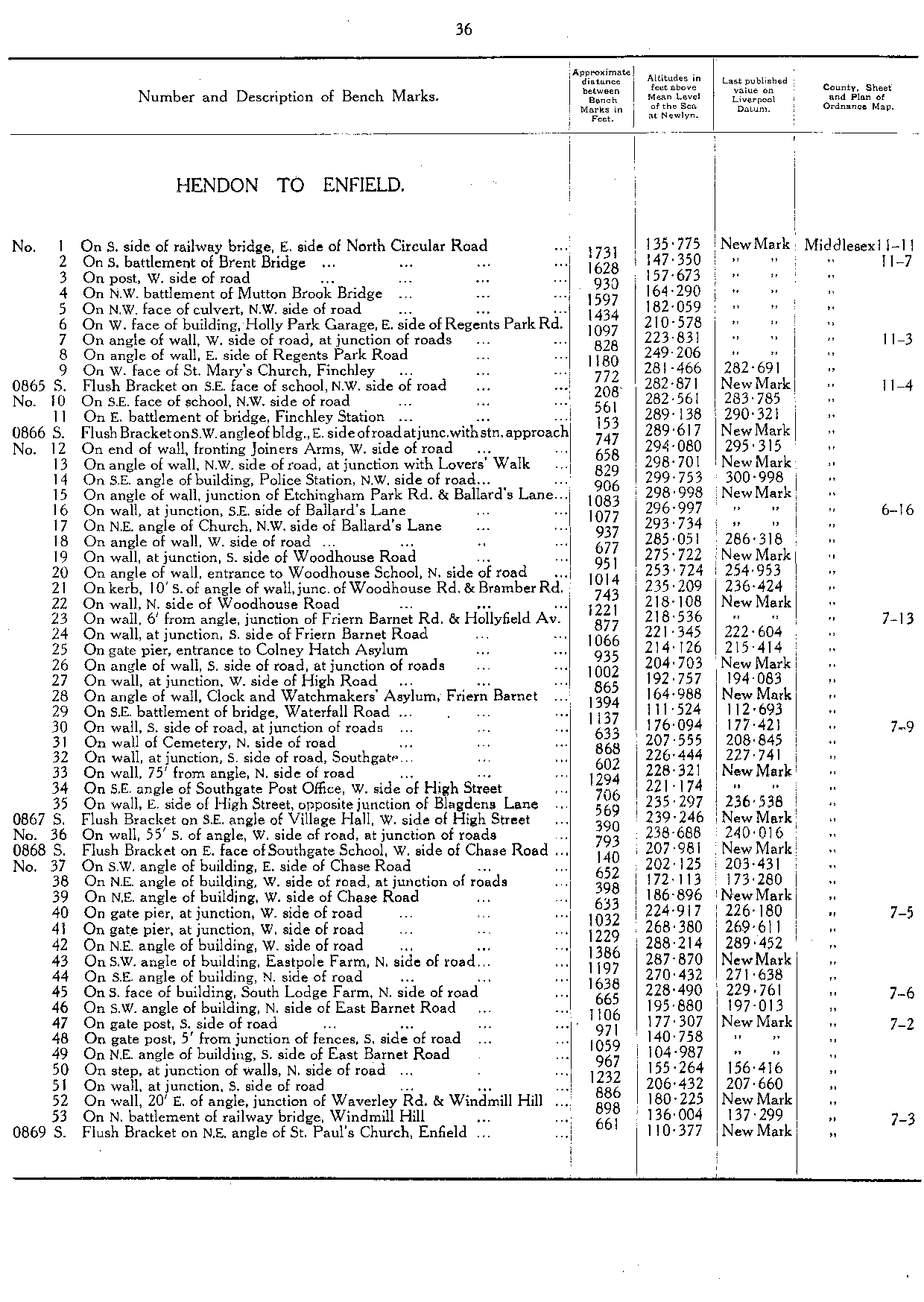
| Hendon to Enfield | | | 36 |
| S0865 | FB on SE face of school, NW side of road [Finchley] | 282.871 | TQ 2508 9062 | 36 |
| S0866 | FB on SW angle of building, E side of road at junction with station approach | 289.617 | TQ 2527 9074 | 36 |
| S0867 | FB on SE angle of Village Hall, W side of High Street [Southgate] | 239.246 | TQ 2965 9411 | 36 |
| S0868 | FB on E face of Southgate School, W side of Chase Road | 207.981 | TQ 2968 9446 | 36 |
| S0869 | FB on NE angle of St Paul's Church, Enfield | 110.377 | TQ 3237 9662 | 36 |
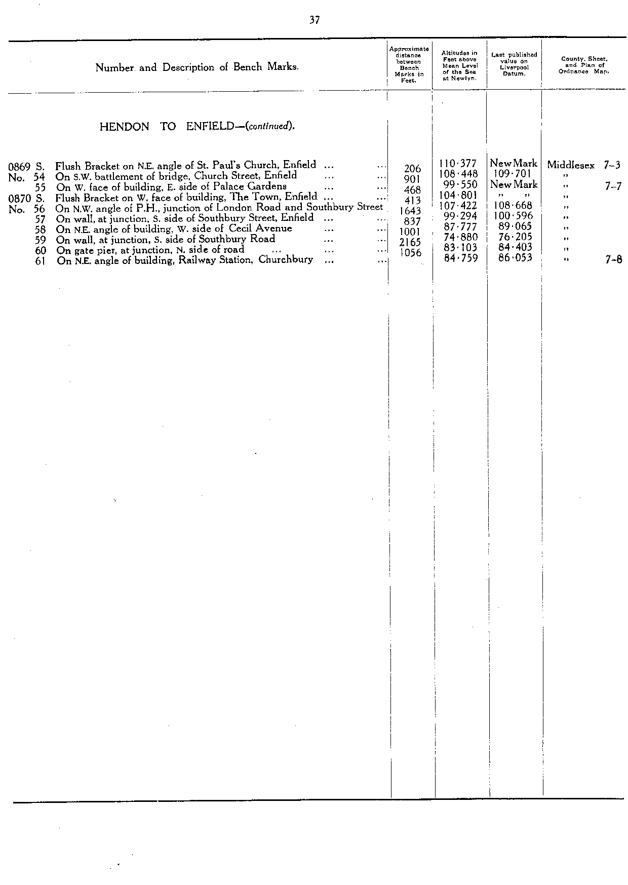
| S0870 | FB on W face of building, The Town, Enfield | 104.801 | TQ 3280 9660 | 37 |
| Ilford to Barking | | | 38 |
| S0945 | FB on SE face of building, Barking Railway Station | 41.38 | TQ 4442 8431 | 38 |
| S0946 | FB on W face of Barking Post Office, E side of Ripple Road | 29.501 | TQ 4437 8415 | 38 |
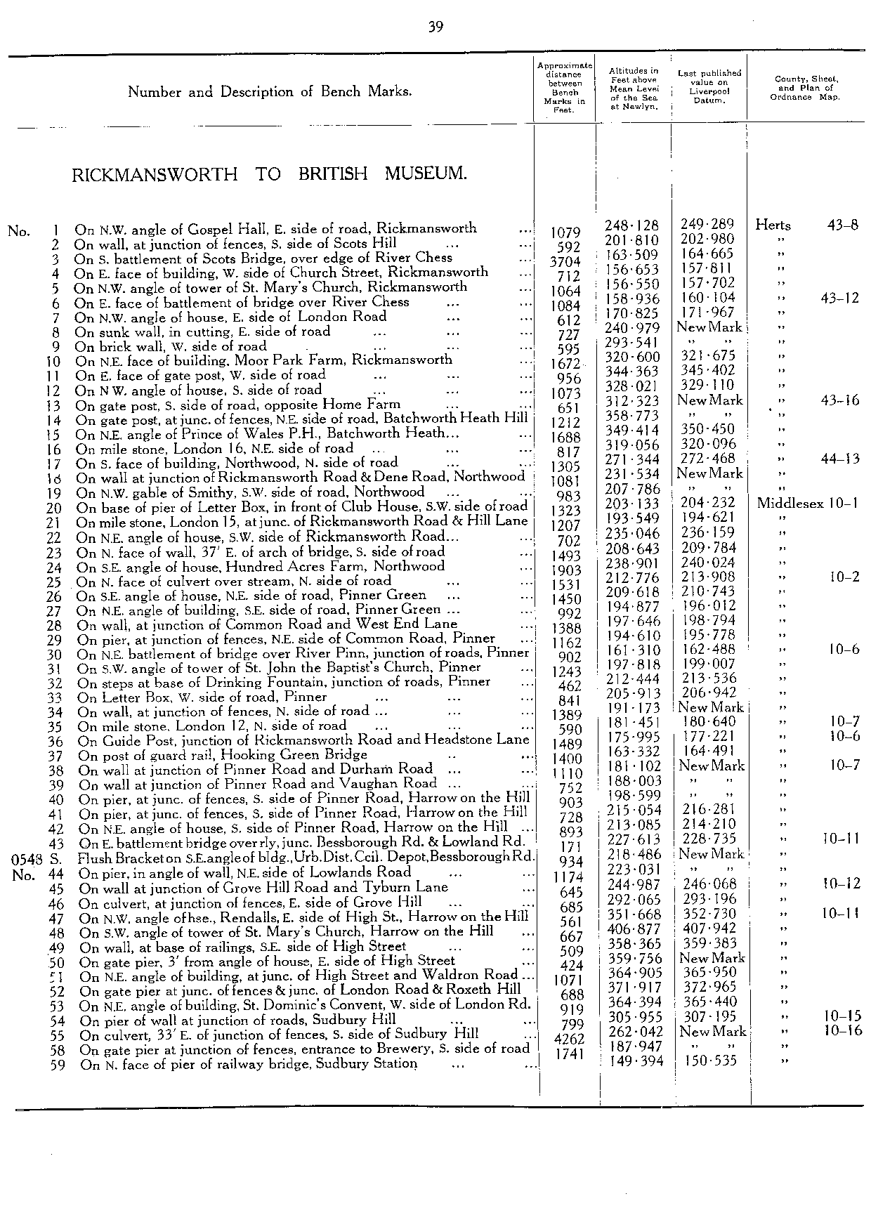
| Rickmansworth to British Museum | | | 39 |
| S0548 | FB on SE angle of building, Urban District Council Depot, Bessborough Road | 218.486 | TQ 1495 8807 | 39 |
| L1 | FB 12' N of SE angle of the British Museum | 86.901 | TQ 3015 8168 | 41 |
| S0549 | FB on E face of Municipal Offices, High Holborn | 77.545 | TQ 3038 8145 | 41 |
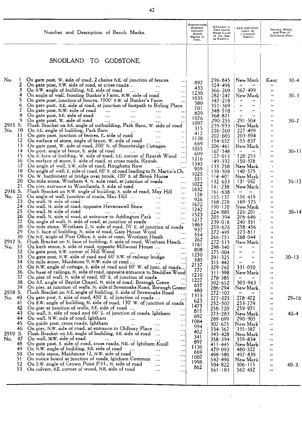
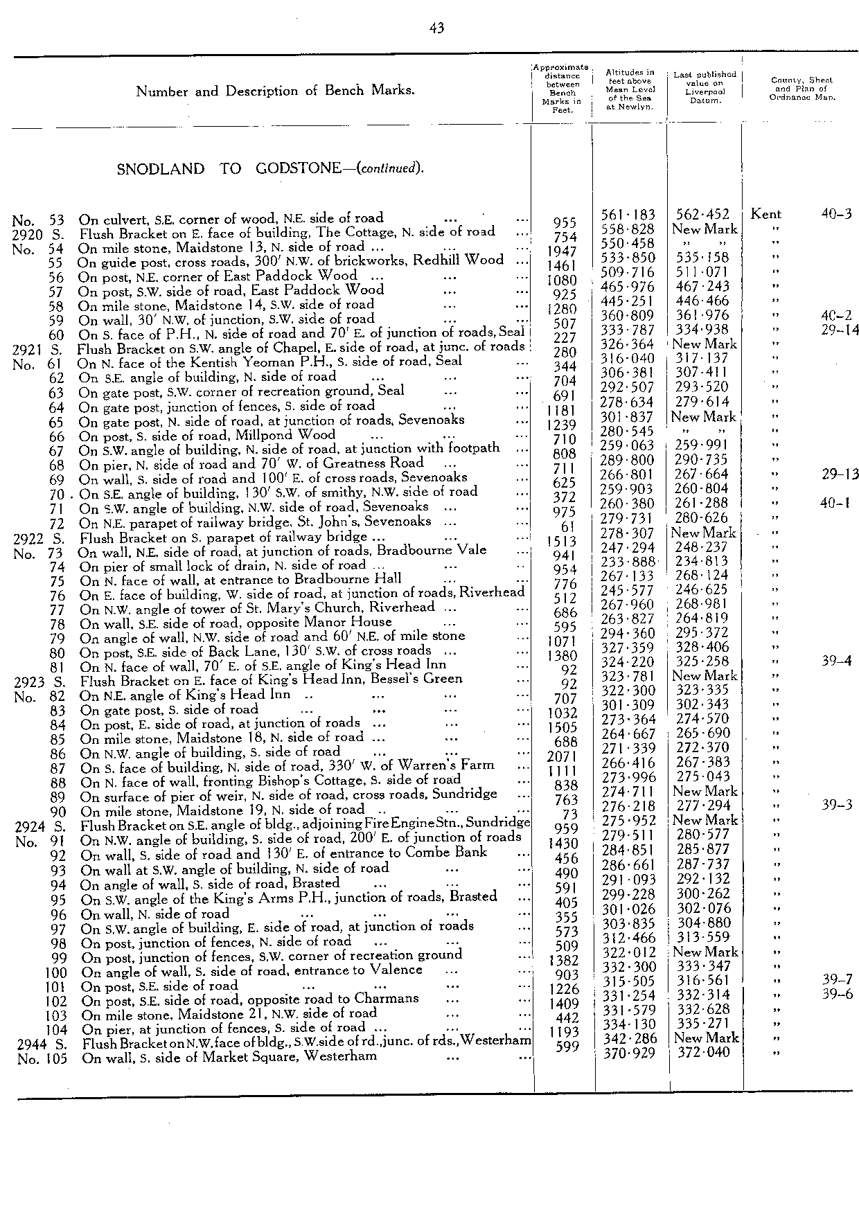
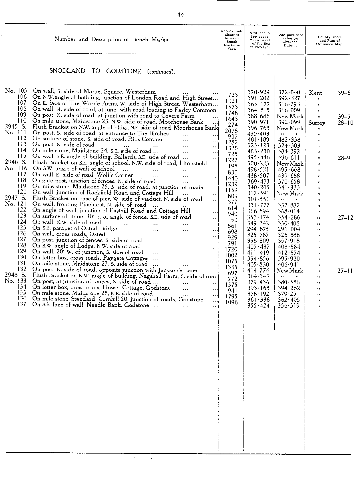
| Snodland to Godstone | | | 42 |
| 2915 | FB on SE angle of outbuilding, Park Barn, W side of road | 235.933 | TQ 6638 6107 | 42 |
| 2916 | FB on NW angle of building, S side of road, May Hill | 161.638 | TQ 6609 5858 | 42 |
| 2917 | FB on N face of building, S side of road, Wrotham Heath | 272.513 | TQ 6332 5800 | 42 |
| 2918 | FB on NE angle of building, S side of Sevenoaks Road | 272.107 | TQ 6061 5728 | 42 |
| 2919 | FB on SE angle of building, SE side of road | 343.428 | TQ 5898 5617 | 42 |
| 2920 | FB on E face of building, The Cottage, N side of road | 558.828 | TQ 5732 5596 | 43 |
| 2921 | FB on SW angle of Chapel, E side of road at junction of roads | 326.364 | TQ 5506 5678 | 43 |
| 2922 | FB on S parapet of railway bridge [St John's, Sevenoaks] | 278.307 | TQ 5255 5644 | 43 |
| 2923 | FB on E face of King's Head Inn, Bessel's Green | 323.781 | TQ 5060 5552 | 43 |
| 2924 | FB on SE angle of building, adjoining Fire Engine Station, Sundridge | 275.952 | TQ 4820 5540 | 43 |
| 2944 | FB on NW face of building, SW side of road, junction of roads, Westerham | 342.286 | TQ 4488 5399 | 43 |
| 2945 | FB on NW angle of building, NE side of road, Moorhouse Bank | 396.763 | TQ 4290 5344 | 44 |
| 2946 | FB on SE angle of School, NW side of road, Limpsfield | 500.223 | TQ 4102 5273 | 44 |
| 2947 | FB on base of pier, W side of viaduct, N side of road | 301.556 | TQ 3948 5259 | 44 |
| 2948 | FB on NW angle of building, Nagshall Farm, S side of road | 364.343 | TQ 3646 5171 | 44 |
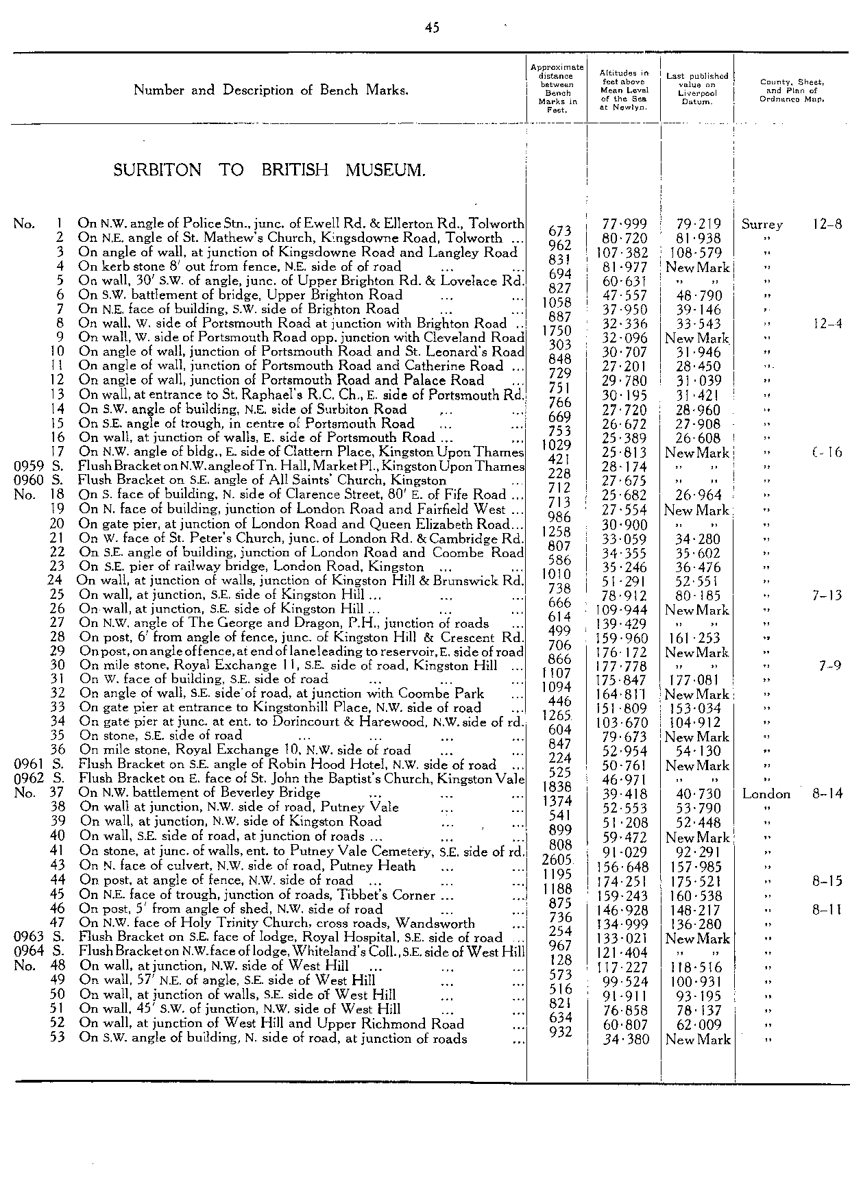
| Surbiton to British Museum | | | 45 |
| S0959 | FB on NW angle of Town Hall, Market Place, Kingston Upon Thames | 28.174 | TQ 1789 6921 | 45 |
| S0960 | FB on SE angle of All Saint's Church, Kingston | 27.675 | TQ 1791 6927 | 45 |
| S0961 | FB on SE angle of Robin Hood Hotel, NW side of road | 50.761 | TQ 2107 7209 | 45 |
| S0962 | FB on E face of St John the Baptists's Church, Kingston Vale | 46.971 | TQ 2113 7194 | 45 |
| S0963 | FB on NW face of lodge, Royal Hospital, SE side of road [Wandsworth] | 133.021 | TQ 2411 7402 | 45 |
| S0964 | FB on NW face of lodge, Whiteland's College, SE side of West Hill [Wandsworth] | 121.404 | TQ 2431 7419 | 45 |
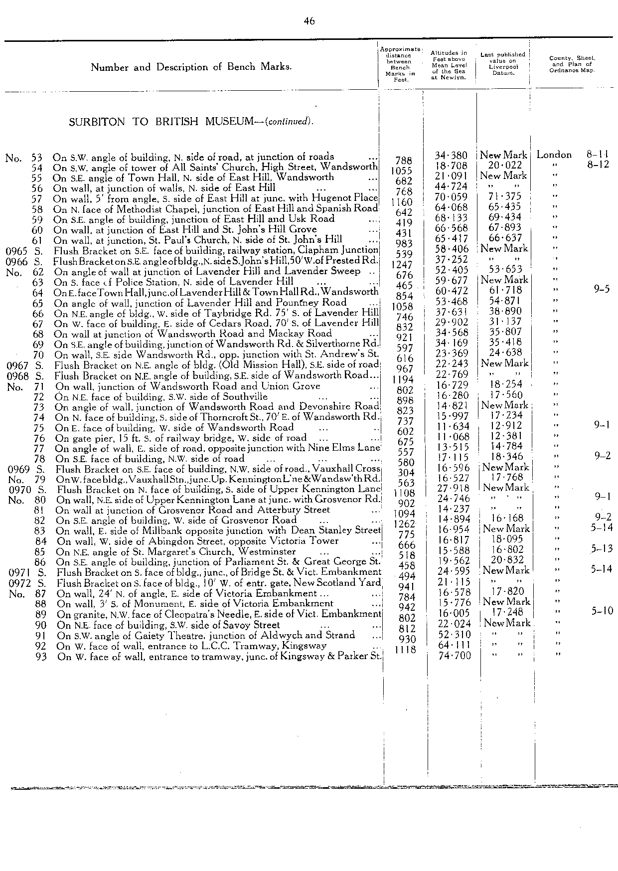
| S0965 | FB on SE face of building, railway station, Clapham Junction | 58.406 | TQ 2709 7536 | 46 |
| S0966 | FB on SE angle of building, N side of St John's Hill, 50' W of Prested Road | 37.252 | TQ 2721 7542 | 46 |
| S0967 | FB on NE angle of building (Old Mission Hall), SE side of road | 22.243 | TQ 2931 7617 | 46 |
| S0968 | FB on NE angle of building, SE side of Wandsworth Road | 22.769 | TQ 2950 7631 | 46 |
| S0969 | FB on SE face of building, NW side of road, Vauxhall Cross | 16.596 | TQ 3027 7795 | 46 |
| S0970 | FB on N face of building, S side of Upper Kennington Lane | 27.918 | TQ 3024 7805 | 46 |
| S0971 | FB on S face of building, junction of Bridge Street & Victoria Embankment | 24.595 | TQ 3029 7967 | 46 |
| S0972 | FB on S face of building, 10' W of entrance gate, New Scotland Yard | 21.115 | TQ 3029 7978 | 46 |
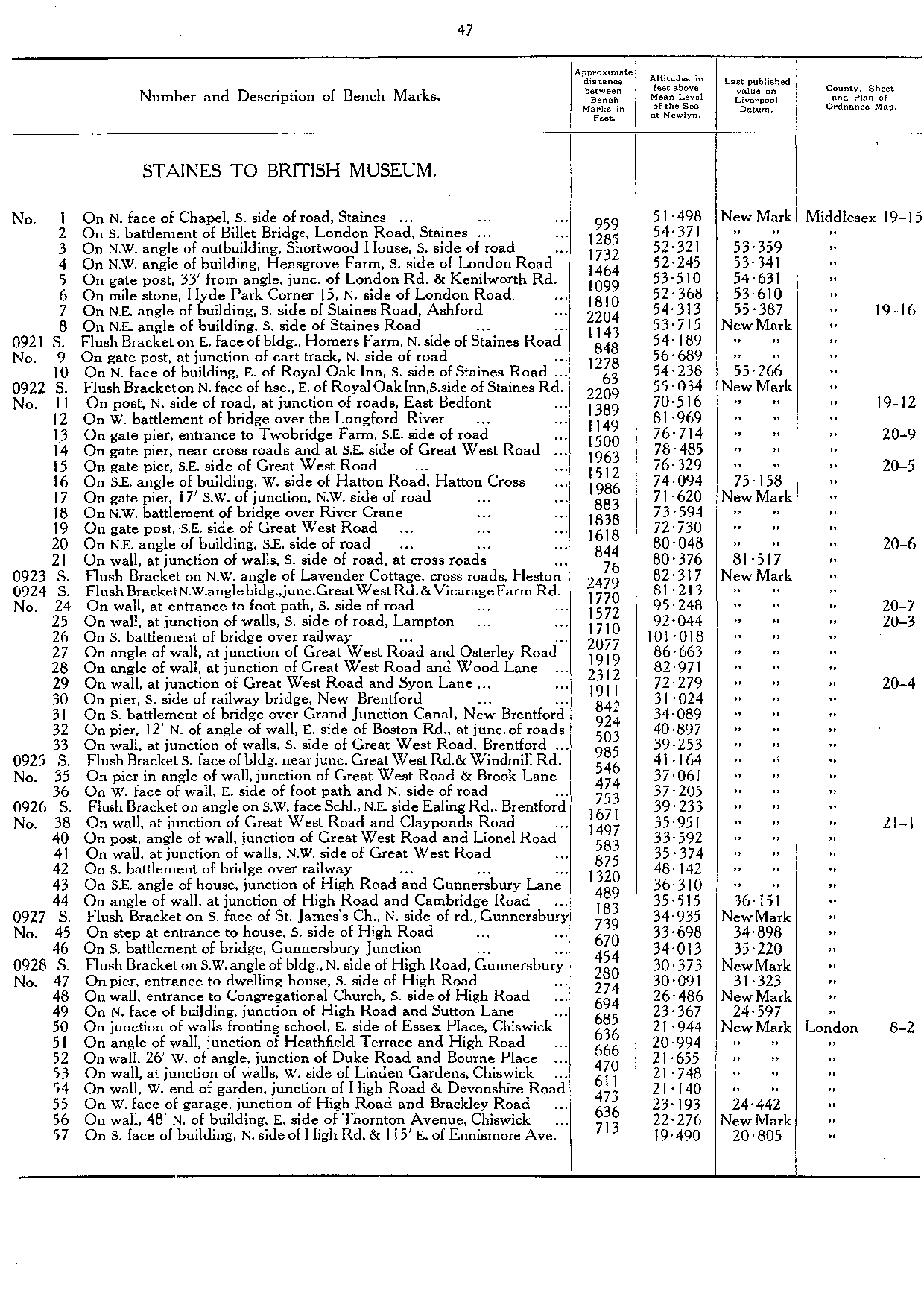
| Staines to British Museum | | | 47 |
| S0921 | FB on E face of building, Homers Farm, N side of Staines Road | 54.189 | TQ 0727 7314 | 47 |
| S0922 | FB on N face of house, E of Royal Oak Inn, S side of Staines Road | 55.034 | TQ 0793 7330 | 47 |
| S0923 | FB on NW angle of Lavender Cottage, cross roads, Heston | 82.317 | TQ 1154 7633 | 47 |
| S0924 | FB on NW angle of building, junction of Great West Road and Vicarage Farm Road | 81.213 | TQ 1231 7647 | 47 |
| S0925 | FB on S face of building, near junction of Great West Road & Windmill Road | 41.164 | TQ 1750 7821 | 47 |
| S0926 | FB on angle of SW face of School, NE side of Ealing Road, Brentford | 39.233 | TQ 1792 7818 | 47 |
| S0927 | FB on S face of St James's Church, N side of road, Gunnersbury | 34.935 | TQ 1951 7845 | 47 |
| S0928 | FB on SW angle of building, N side of High Road, Gunnersbury | 30.373 | TQ 2003 7854 | 47 |
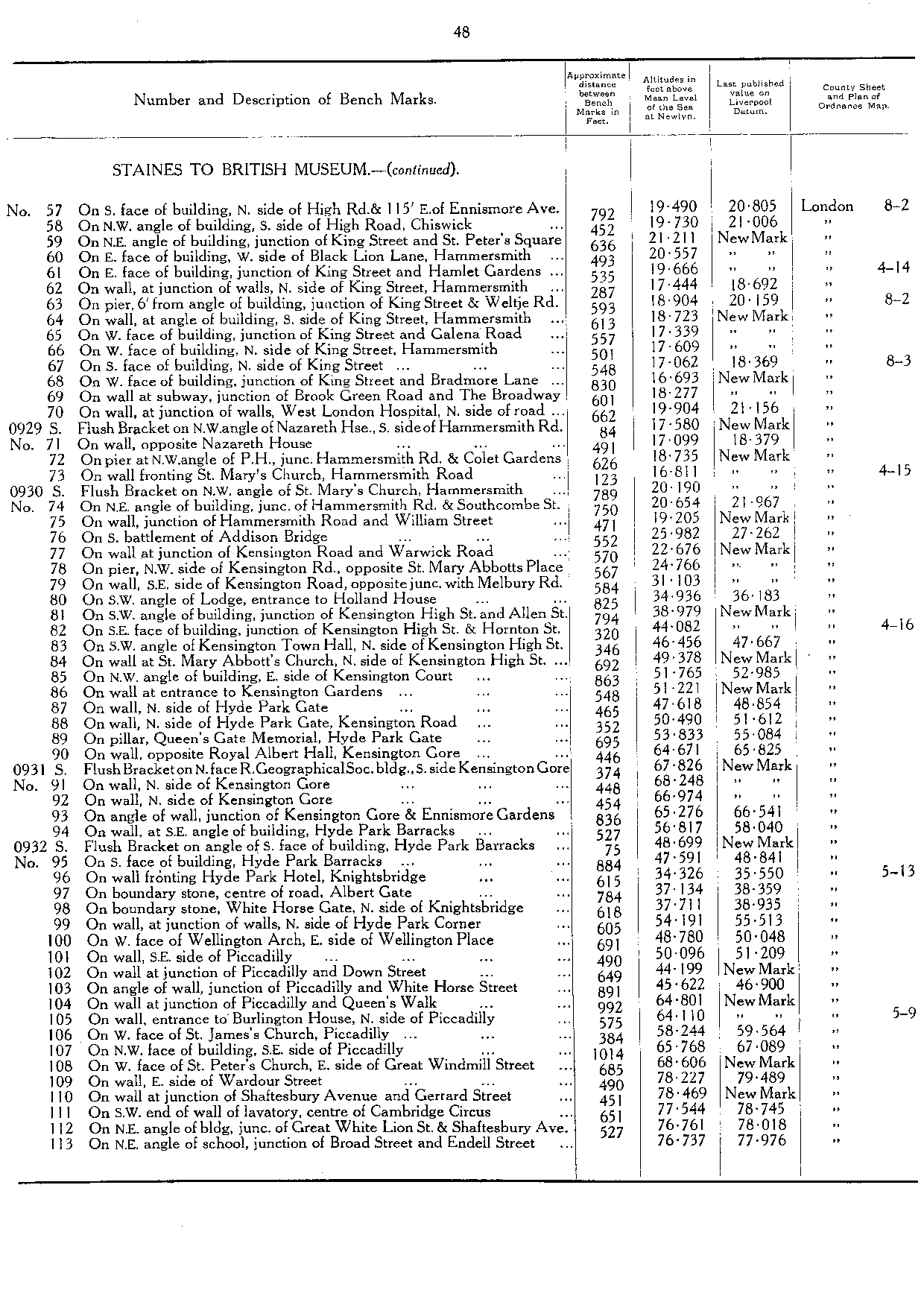
| S0929 | FB on NW angle of Nazareth House, S side of Hammersmith Road | 17.58 | TQ 2374 7861 | 48 |
| S0930 | FB on NW angle of St Mary's Church, Hammersmith | 20.19 | TQ 2405 7870 | 48 |
| S0931 | FB on N face, Royal Geographical Society building, S side Kensington Gore | 67.826 | TQ 2677 7964 | 48 |
| S0932 | FB on angle of S face of building, Hyde Park Barracks | 48.699 | TQ 2750 7971 | 48 |
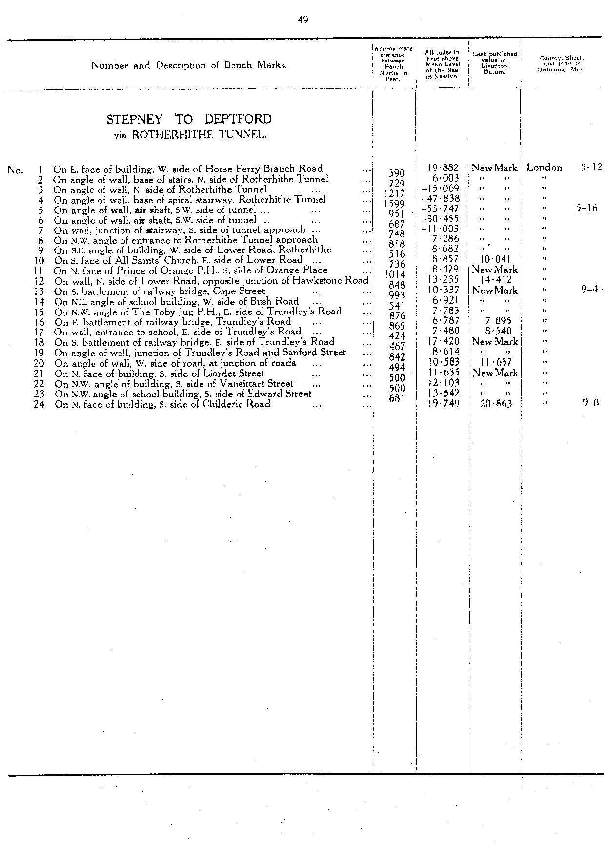
| Stepney to Deptford (via Rotherhithe Tunnel) | | | 49 |
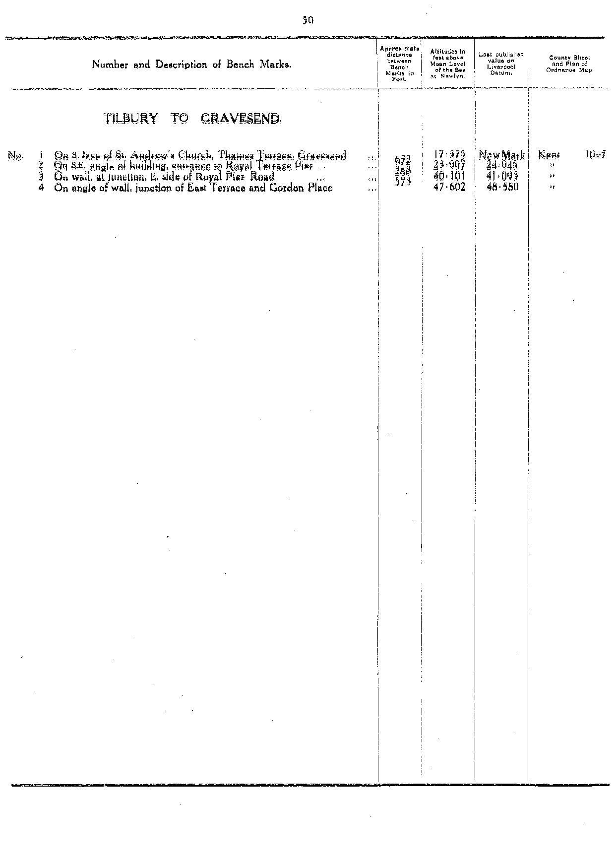
| Tilbury to Gravesend | | | 50 |
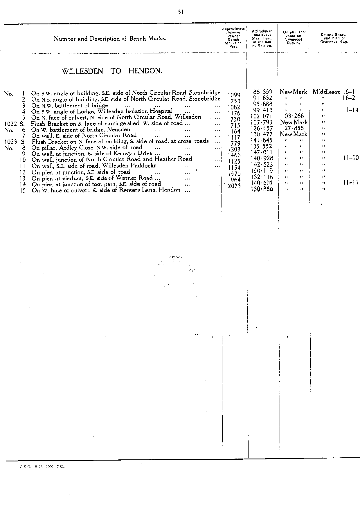
| Willesden to Hendon | | | 51 |
| S1022 | FB on S face of carriage shed, W side of road | 107.793 | TQ 2114 8534 | 51 |
| S1023 | FB on N face of building, S side of road at cross roads | 141.845 | TQ 2115 8606 | 51 |